THE BEAST OF SABAH
I
will come over and conquer the whole of you.
The moment I stepped myself out of
the airport, I inhaled the tranquility of the land and the crisp of its fresh
air takes me back to the state peace of mind. I have waited five months for
this thrilling experience, making another dream come true and another ticking things
off my bucket list as a prove to my
achievement. From where you stand, there were already a lot of taxi and
grab drivers waiting to get you to any destinations that you are wishing for.
Known as the ‘Land Below The Wind’,
the 72, 500sqkm Sabah is one the 13 member states of Malaysia that falls just
below the typhoon belt of Philippines. To land yourself in Sabah, you have to
go through Sabah’s capital, Kota Kinabalu, if you are flying from the Malaysian
eastern gateway. The state is filled with a rugged landscape of marshy,
mangrove-tangled coastal areas, lush paddy fields, dizzy heights of mountains
and also a home to a number of wildlife. My motive on the land of Sabah this
time was simple – to climb the Mount of Kinabalu. As an avid hiker, I stepped
up my workout routine to prepare myself mentally and physically before I hike
the beast of Sabah. I have booked my hike for 3 months prior, there is no way
for you to book your hiking 2 weeks before.
My bags were loaded in the back of the car by a middle-aged man. The host, Peter, arranged a taxi for me from Kota Kinabalu Airport to my Airbnb in Kundasang before my climb the next day. The 2 hour drive feels just like when you are reaching the peak of Cameron Highlands, the weather turns pretty chilly, except the road to Kundasang is very narrow and bumpy. Upon arrival, I was greeted well by Peter and Lily in their Magic Mountain Country Home. They made sure that I was comfortable and rested well.
By 6AM in the morning, Peter helped
to get me situated and ready for my climb by driving me to Park HQ. The
registration, accommodation and meals sorted with Sabah Parks were very quick
and efficient. I had signed up for a two-day hike, I was also given an ID tag
that was required for my checking in and out of the mountain accommodation
including passing through checkpoints. This is to ensure that Sabah Parks knows
who, where or when is on the summit trail. I was then assigned to a mountain
guide, Andy, and we hopped on the shuttle bus to Timpohon Gate, the starting
point of the climb. The distance from Park HQ to Timpohon is around 4.5
kilometers and it only took us approximately 15 minutes.
The hints of the morning breeze, send shivers down
to my spine. This should be a piece of cake, I thought. I had to cover the
first 6 kilometers mark (3,3000 meters above sea level) of the mountain trails with
an average climbing time 4 to 5 hours, on day one. I started my climb around
10AM and on the first 2 kilometers of climbing up, I already felt that my
decision was ridiculous. I had to carry an amount of 23kg load on my back and
trying my best to not slip as the slopes were quite slippery from an earlier,
truly an extreme sport. Anyone who failed to firm their foothold on the stairs
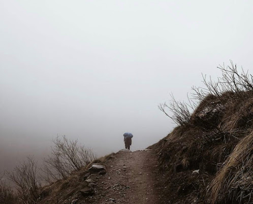
and rocky terrain could result a nasty fall, at this time. The fog started to
roll in and the weather is getting colder as we climb, my legs were fine but I
anticipated breathing difficulties due to altitude sickness when we were about
2,000 meters above sea level. My chest were tight, my lungs were struggling to
function. I had no choice but to stop every 20 minutes to catch my breath.

I halted at the Layang-Layang Shelter, 4 kilometers
mark, for my lunch. Whilst enjoying the world from different perspective, I
realized that my climb was not mainly on the physical challenge but a botanical
journey and biological diversity. I get to catch glimpses of uncommonly seen
plants along the Kinabalu trails, different vegetation zones and rare species
of Oak, Chestnut which make a good photography subject along my way. The
presence of these exotic plants scilicet the carnivorous pitcher plants and the
parasitic Rafflesia definitely added more charm to the ancient forest. When I
thought of the first 4 kilometers were insane, it was nothing compared to the
next 2 kilometers up to the rest house. The trail got steeper and rockier, the
most difficult phase arose when I was at the final kilometer.
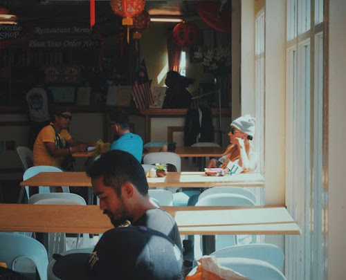 |
| Laban Rata Restaurant, Panabalan. |
I pushed
myself hard as I could to reach the base camp, Laban Rata for our overnight
rest. The air was dry and cold. From witnessing the forest canopy into a
landscape of huge trees that resembles bonsai which reminded me of Japanese
garden, I could slowly see through the little guesthouse nestled into the
mountain side. My climb ended at the 6 kilometers mark (3,300 meters above sea
level) at 5pm, 2 hours late. Andy pat my shoulder on my achievement that evening
despite almost bursting out my lungs. The picturesque view high above the sea
level was stunning. The plots of vegetation was riveting, while the unique
plots of the waterfall cascading down reminded me so much of the days in my
hometown when I used to go to a waterfall with my old friends. I grabbed my
dinner quickly after and headed to bed.
Getting ready at 2AM for day two, I was thrilled to
complete the rest of my climb. It was drizzling and windy, and we continued to
ascend 2.7 kilometers long to the summit in the hope to arrive before the
sunrise. We made a slow progress in the pitch dark with our headlamp and
flashlights. The trail got steeper as we were reaching to the peak and I was
already imagining the most horrible plummet to my own death. Some of the
climbers had to stop and turned back due to altitude sickness, leaden limbs and
nausea due to low oxygen. I could not feel my limb up to that point but I did
not want to let my efforts go to waste. I channeled my energy into each of my
step than letting the whole situation consumed me. The air was getting thinner
and we used the ropes to push ourselves up. There were no vegetation left, only
massive bare granite slab, smoothed and furrowed by long-extinct glacier.

Eventually, we managed to reach Mount of Kinabalu
around 6AM. We were greeted by an icy blast of wind and a view of thick white
clouds. I exhaled the loudest when I stepped my foot on the tallest mountain in
Malaysia. Mount Kinabalu is the highest peak of the Bornean Crocker Range, with
an altitude of 4095 meters above sea level and that marks my almost 9KM climb. I
sit as I found my beautiful spot to witness the splendid sun rising above the
horizon in the distance. It was mesmerizing to watch the rising of the huge
ball of fire amidst the splashes of warm hues of red, orange and yellow.
Everyone was silent, enjoying the spectacular view which was truly
breathtaking. As the sun rose futher, the mist over the valleys that formed a
sea of clouds below, really had me feels like I was on top of the world looking
down at all creations.

The dirt tracks, wooden planks, rocky and stoney
path to this summit including my ability to endure all the hurdles, worth all
my sweats. Experiencing a bird’s eye view of mountain vistas when the sun arose
was awe-inducing. A sighed of relief, overwhelmed with happiness and sense of
contentment. The climb was like a walk through the history, never cease to
amaze with its phenomenal landscape.
I have conquered whole of you and it was remarkable.


Comments
Post a Comment